

Revolutionary War Encampments: Rochambeau and the Art of Moving Troops
Artifacts recovered from the historic route of the French Army’s march to and from the 1781 Battle of Yorktown lead archaeologists toward a surprising discovery and more field work.
By Michael Clem | DHR Eastern Regional Archaeologist
As is typical with my job as archaeologist of Virginia’s Eastern Region, I receive numerous calls each week about a wide variety of topics. It’s something different every day. In early March of 2026, I received an email from Johnny Carawan, the administrator of the Washington-Rochambeau Revolutionary Route National Historic Trail. He reported to me that he had been informed of some metal detectorists finding Revolutionary War uniform buttons and other items. He was interested in the objects recovered since they were found along the historic route of the French Expeditionary Force’s march before and after the Battle of Yorktown. I had not thought much about the role of the French Army during the American Revolution until now. After several exchanges with Carawan, it became clear to me that this discovery had happened on private property and that the metal detectorists had permission to search at the location. There were no protective easements on the property. DHR essentially had no jurisdiction. The site was known to have served as a Civil War encampment as well, a fact that drew the detectorists to the property initially.
The owner of the property—a private foundation—was set to receive all the materials recovered by the detectorists. The foundation agreed to allow DHR and others come to view the collection. My first visit took place in late March. Kerry S. González, the National Park Service’s Chief of Cultural Resource Management at George Washington Birthplace, accompanied me on the trip. We worked closely as the leads on the project. I also asked my colleague, Jonathan Connolly, an archaeologist and project reviewer at DHR, to join us on the trip. Jonathan was, at one time, an NPS employee at Yorktown, the site of where the French Army aided the Continental Army in 1781 to defeat the British forces during the Revolutionary War. His knowledge about the American Revolution and the French Army’s role in it is outstanding. Indeed, much of what we’ve accomplished in our research on the topic relied on his assistance and guidance.
During our visit, we saw that the detectorists had filled roughly 10 large glass-covered display cases with items collected in the fields on the historic route. There were also several buckets of horseshoes and other larger metal fragments. Of these cases, only one was dedicated to items from the 18th century. The case included several different mid-century coins, including ones of English, Spanish, and French origins. There were also uniform buttons from a variety of French infantry and artillery units. We were informed that all of the 18th-century items were recovered from one field in the southwest corner of the property.
After our visit, Jonathan and I regrouped at DHR to begin our education—or, at least I did—of the trek of Rochambeau’s army from New England to Yorktown in 1781, and their subsequent return northward in the late spring of 1782. Jonathan, far ahead of me, was able to locate the French engineers’ maps of the journey northward. We were also able to find an overall map of the journey, which showed the general location of each numbered encampment. These camps were labeled as “Marche” on the trip south, with the numbers beginning in Providence, Rhode Island, and continuing all the way to Yorktown. The journey north had locations labeled as “Camp”, with the first one in the Yorktown vicinity and moving northward, increasing in number all the way back north. While no individual maps of the “Marche” locations have been found, the “Camps” were each sketched in detail, labeled with a place name and number, and included roads, water features, and terrain. The maps were also later made quite stunning, featuring watercolors as well as details designating the locations of troops and artillery. The maps proved very useful, and I was able to take the individual camp location that we had visited in March and match the road, stream, and terrain to determine that we were, indeed, in the correct location as drawn by the French engineers.
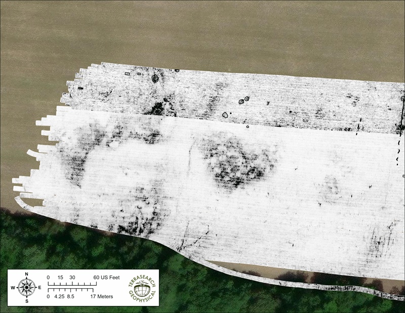
Subsequent trips to the camp included bringing along a team of geophysical scanning experts, who conducted both a ground penetrating radar survey and a magnetometry survey of the area. These non-destructive surveying methods allow archaeologists to see underground anomalies, such as backfilled pits and trenches, foundations, burials, and more. The surveys were conducted by TerraSearch Geophysical, LLC. Unfortunately, the field was generally void of any large features. What was evident were groundhog burrows, deep plow scars, and old tree roots along the field borders.
The next step was to try our hand at systematic metal detecting in a grid pattern. For this, we were able to connect with Joe and Mary Jane Balicki, who run training courses for professional archaeologists to learn the proper methods of metal detecting at historic sites. The Balickis took a week to try their hand in this field. While they found a great many items, none were related to the French occupation at the site. In the end, we concluded that the camp had been kept clean at the time of occupation, with any remnants erased by subsequent plowing and the occupation of the Union Army that stayed at the same location decades later, or, that the metal detectorists had found all there was to be found. It became obvious that further work at the site would likely yield little information. We decided to regroup once more and find solutions to study these elusive camps.
In our ongoing research, Jonathan came across Rochambeau’s marching orders. These were handwritten, faded, and in French, so translation was difficult. I sent them to a native French speaker to translate. From these orders, we were able to determine that each overnight encampment was to be laid out at a very precise and consistent distance from the last camp. The distance measured approximately the limit possible for a group of soldiers to march in a day and took into consideration all of the wagons and equipment, along with artillery. What we also found was that the French army sent out a team of engineers ahead of the troops to clear areas and set up each camp. After a few days, the first group of soldiers would begin the journey. Approximately 1,000 troops would march out and occupy the first camp. The next day, a second group of equal size would embark on the journey, and so on. This meant that each night, a different group of soldiers would occupy the camp until the entire army had gone through on their way northward.
Using the individual maps and the knowledge we had gained, I decided to trace backwards and find the estimated location of other camps. In doing so, I found one camp with a road name that is still in use. The map of the camp shows a location between very dramatic terrain features, a small stream, and a winding side road. It wasn’t difficult to find the spot using modern topographic maps. The location is quite rural, and the roads and topography have remained unchanged. Using the county property tax GIS system, I was able to find the name of the parcel’s owner. I sent an old-fashioned letter explaining my interest in visiting the property. I expected little. Two weeks went by and, finally, my phone rang. It was the owner, and she was excited to hear that her property may be historically significant. We set up a date to meet.
Upon my initial visit to the site, I was struck by the accuracy of the 244-year-old maps drawn by the French engineers. The roads and terrain were exactly as pictured. The property is now a mix of young trees in abandoned fields and older trees along the south end. An antebellum house stands on the property as well, dating to some 60 years after the encampment. The house was well north of the area shown to be where the infantry troops were camped and south of the artillery camp. I showed the owner the maps we had and pointed out an area I was interested in seeing. However, the area was well-covered in greenbrier and dense vegetation, making it virtually impossible to explore. The owner promised to mow the area with a tractor. A return trip was planned. As I was arranging this, Jonathan had begun studying lidar imaging of the area. He had spotted an unusual anomaly in the landscape. Immediately, we were intrigued.
Following additional research, Jonathan and I concluded that we likely found a camp kitchen.
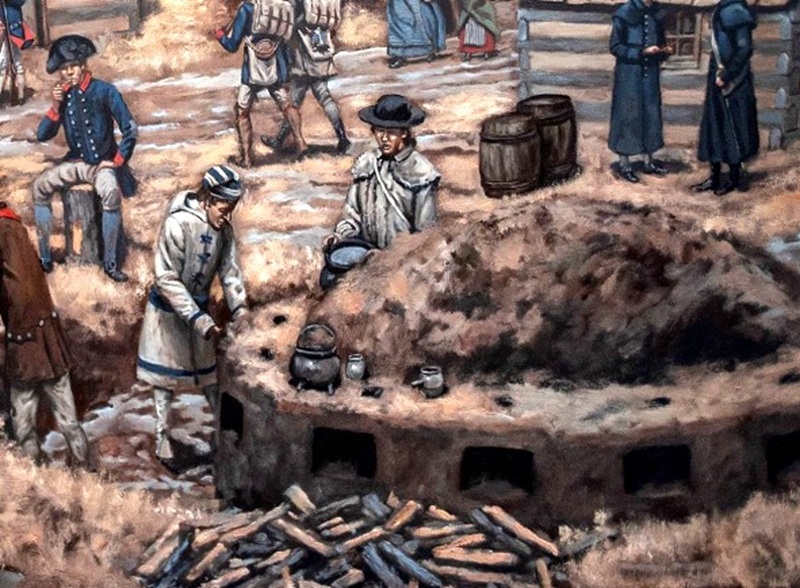
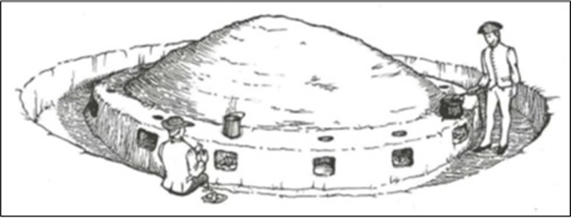
A study conducted by TerraSearch Geophysical revealed remnants of one of these kitchens. Further study identified another such feature associated with a partially intact kitchen at a British camp in Gloucester County. It was seemingly common practice during the time of the war for the army to excavate a large circular trench, perhaps 30 feet in diameter or so. The soil from the trench was piled and compacted in the center, and a circular shelf was created along the path of the trench. In that shelf, at regular intervals, a shallow alcove was burrowed out horizontally and then turned upward to create a hole above the alcove. Each alcove would hold a small fire, and on the hole in the top, a pot was set to cook stew. There would be a dozen or so of these all the way around the shelf. The cooks would stand in the trench and be able to circle around to tend multiple pots simultaneously. This appeared to be an efficient way to cook for a large group. According to manuals of the period, there was supposed to be one kitchen of this type for each company. A typical camp would contain several kitchens. It is unclear if the French adhered to this practice on the march northward. What we can say is that no one has ever found a kitchen fully intact, until now. Jonathan and I believe we have found one that was never destroyed in a wooded section of the property. It appears larger than the ones that have been reported before, and larger than the regulation size. The site of the kitchen is in an area that has never been plowed. The area has been wooded since the 18th century, when the camp was established. Trees in the area are roughly 150-200 years old. There are also stumps of very large and long-dead trees.
At the time this article was published, we have not begun archaeologically testing the area. That will probably happen in the coming months. What is certain is that the kitchen site sits within the limits of an area shown on the French maps as the infantry camp. An old overgrown field lies some 50 feet away from the site. It may be possible that other features like that of the kitchen were plowed (and thus left invisible on the surface), but remnants may have been left behind underground. I plan to follow up on this effort as soon as I have something more to report.
Legal Disclaimer:
EIN Presswire provides this news content "as is" without warranty of any kind. We do not accept any responsibility or liability for the accuracy, content, images, videos, licenses, completeness, legality, or reliability of the information contained in this article. If you have any complaints or copyright issues related to this article, kindly contact the author above.
